Paul Bourke : Fractal Landscapes
Introduction
Fractal landscapes are often generated using a technique called spatial
subdivision. For magical reasons this results in surfaces that are similar in
appearance to the earths terrain.
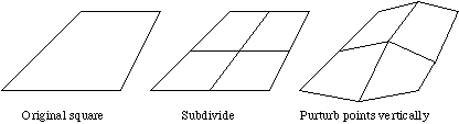
The idea behind spatial subdivision is quite simple. Consider a square on the
x-y plane,
(1) split the square up into a 2x2 grid
(2) vertically perturb each of the 5 new vertices by a random amount
(3) repeat this process for each new square decreasing the pertubation each
iteration.
 The controls normally available when generating such landscapes are:
* A seed for the random number generator. This starts the rundom number
generator and means that the same landscape can be recreated by remembering
only one number.
* A roughness parameter. This is normally the factor by which the
perturbations are reduced on each iteration. A factor of 2 is the usual
default, lower values result in a rougher terrain, higher values result in a
smoother surface.
* The initial perturbation amount. This set the overall height of the
landscape.
* Initial points. It is often desirable to specify some initial points,
normally on the corners of the initial rectangles. This provides some degree
of control over the macro appearance of the landscape.
* Sea level. This "flood" the terrain to a particular level simulating the
water level.
* Colour ramp. This is used for shading of the terrain surface based on the
height. Normally two or three colours are defined for particular heights, the
surface at other heights is linearly interpolated from these points.
* Number of iterations. This results in the density of the mesh that results
from the iteration process.
The controls normally available when generating such landscapes are:
* A seed for the random number generator. This starts the rundom number
generator and means that the same landscape can be recreated by remembering
only one number.
* A roughness parameter. This is normally the factor by which the
perturbations are reduced on each iteration. A factor of 2 is the usual
default, lower values result in a rougher terrain, higher values result in a
smoother surface.
* The initial perturbation amount. This set the overall height of the
landscape.
* Initial points. It is often desirable to specify some initial points,
normally on the corners of the initial rectangles. This provides some degree
of control over the macro appearance of the landscape.
* Sea level. This "flood" the terrain to a particular level simulating the
water level.
* Colour ramp. This is used for shading of the terrain surface based on the
height. Normally two or three colours are defined for particular heights, the
surface at other heights is linearly interpolated from these points.
* Number of iterations. This results in the density of the mesh that results
from the iteration process.
FracHill
An application that creates fractal landscapes has been written by myself called
FracHill. It fully implements fractal terrain generation including control over
(x,y) range, sea colour, background colour, terrain colour ramp, lighting,
rendering options, camera attributes, grid density, 9 initial points, height
variation, and roughness.
This application runs on any Macintosh computer with colour QuickDraw. It
supports image saving to PICT files and colour printing through the standard
Apple printing mechanism.
It also has the ability to geometrically morph between any two terrain models,
images or models can be automatically exported and formed into animation
sequences.
FracHill was primarily written as a creator of terrain models for other 3D
modelling and rendering packages and thus provides the ability to export the
land surface in a number of CAD formats so that it can be imported into 3D
modelling packages.
At the time of writing it exports to the following file formats
DXF
Siper3D
Radiance
RayShade
POV-Ray
points
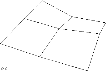
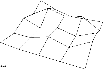
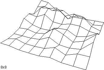
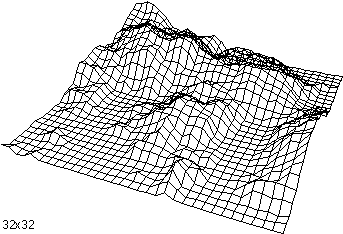
The following shows a terrain surface at various grid resolutions from 2x2 to
32x32.
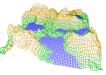
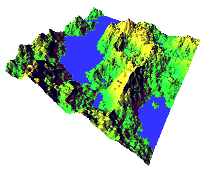
 In addition to wireframe views, FracHill performs other types of rendering
including
hiddenline
coloured
shaded
Some examples directly from FracHill are shown below
In addition to wireframe views, FracHill performs other types of rendering
including
hiddenline
coloured
shaded
Some examples directly from FracHill are shown below
 A well known artifact (bug) with terrains generated this way is the appearance
of "seams" or "creases". These generally occur along the edges of the geometry
associated with early iterations. A clear example is shown below, notice the
crease in the bottom left part of the terrain highlighted by the shadow zone:
A well known artifact (bug) with terrains generated this way is the appearance
of "seams" or "creases". These generally occur along the edges of the geometry
associated with early iterations. A clear example is shown below, notice the
crease in the bottom left part of the terrain highlighted by the shadow zone:
References
Heinz-Otto and Dietmar Saupe, The Science of Fractal Images, Springer-Verlag
The Synthesis and Rendering or Eroded Fractal Terrains, F.Kenton Musgrave,
Craig E Kolb, Robert S. Mace, IEEE Computer Graphics & Applications